Magellium: supporting the development of the Copernicus Land High-Resolution Snow and Ice Monitoring service
The WEkEO platform is used by a variety of organisations for different purposes from scientific research and environmental monitoring, to supporting the development of fact-based policy making and commercial applications of Earth Observation data. The WEkEO team spoke to Joel Dorandeu from Magellium to discuss how they have used the WEkEO platform to develop and operate the Copernicus Land Monitoring Service (CLMS)’s High-Resolution Snow and Ice Monitoring service on behalf of the European Environment Agency (EEA), which implements the pan-European and local component of the CLMS.
What does Magellium do?
Magellium is an innovative company founded in 2003 in Toulouse that specialises in geoinformation and image processing. Under delegation from the EEA, and in collaboration with Astri Polska, Cesbio and Météo-France, they led the development and operation of CLMS’ High-Resolution Snow and Ice Monitoring (HRSI) service.
What is the High-Resolution Snow and Ice Monitoring service?
The High-Resolution Snow and Ice Monitoring (HRSI) service provides high resolution data on fractional snow cover, persistent snow area, river and lake ice extent and aggregated river and lake ice extent for the 32 EEA member countries, United Kingdom and 6 cooperating countries in the Western Balkans.
Snow and ice cover monitoring is critical in many ways: it is an important parameter for weather and hydrology forecasting, as well as for water management, and is thus essential for predicting and managing natural hazards such as floods, avalanches and river ice jams. Furthermore, snow cover and lake ice cover are two of the 50 essential climate variables (ECVs) which are monitored to support the work of the United Nations Framework Convention on Climate Change and the Intergovernmental Panel on Climate Change.
Finally, this information also supports the winter tourism, agriculture and forestry, hydroelectric power generation or water supply sectors.
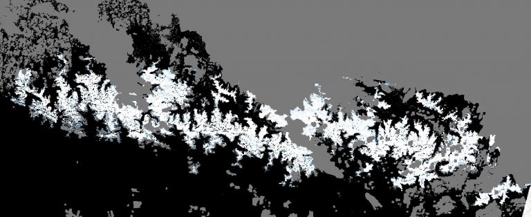 Snow Ice extent in the Pyrenees (from the Fractional Snow Cover product within the HRSI service) | Copernicus Land Monitoring Service 2021, European Environment Agency (EEA)
What are the benefits of WEkEO for this project?
The HRSI service was developed and is operated entirely on the WEkEO platform. Three characteristics of the WEkEO platform have been key to the successful implementation of this service: the availability of Sentinel data, notably Sentinel-2 data; the consistency and sustainability of the WEkEO platform; and the cloud capabilities and infrastructure, such as the virtual machine and dynamic CPUs. Thanks to these characteristics, we have not faced any major problems and will be able to continue to operate and update the HRSI smoothly for the foreseeable future.
What WEkEO plan and processing environments have you used?
For this service, Magellium uses fixed yearly reserved virtual machines for the system (around 10 virtual machines with various flavours) and pay-per-use virtual machines for the actual processing (up to 400 virtual machines in parallel). Additionally, we use fixed yearly reserved object storage (S3) for the catalogue data.
What data does the service use?
The HRSI service uses mainly Sentinel-2 data, and in a second phase, Sentinel-1 SAR data (products expected for mid-September 2021), which are all available and downloadable through WEkEO.
What data is available through WEkEO?
The HRSI project highlights the benefits of WEkEO in terms of the availability of environmental and Sentinel data. Indeed, WEkEO provides access to data from Sentinel-1, -2, -3 and -5P, as well as data and products from the four Copernicus Services focused on environmental data (marine, atmosphere, climate and land). Since WEkEO is implemented by the institutions in charge of generating Copernicus data and products, the data infrastructure between those institutions and WEkEO is directly linked, rather than being duplicated. WEkEO users thus benefit from the most up-to-date Copernicus environmental data, directly from the source. Moreover, users benefit from the expert support, trainings, and uptake resources directly from the organisations that produce the data.
More Information
Copernicus Land Monitoring Service (CLMS)
Copernicus Climate Change Service
Copernicus Atmosphere Monitoring Service
The High-Resolution Snow and Ice Monitoring service