COVERAGE: Enabling the widespread use of satellite and in-situ ocean data for societal benefit
The WEkEO platform is used by a variety of organisations for different purposes from scientific research and environmental monitoring, to supporting the development of fact-based policy making and commercial applications of Earth Observation data. The WEkEO team spoke to Dr. Vardis Tsontos from NASA JPL, the driving force behind the COVERAGE project, to discuss how they use the WEkEO platform to access Copernicus Marine Environment Monitoring Service data and promote the usage of Marine data.
![]()
What is COVERAGE?
COVERAGE is a cross-cutting, formal initiative within CEOS, which addresses key constraints to the uptake of marine data and enable a more widespread use of satellite and in-situ ocean data in support of open science and applications for societal benefit.
COVERAGE involves the implementation of a cloud-based technology platform, providing access to curated interagency satellite data from the 4 ocean virtual constellations - sea surface temperature, ocean surface vector winds, ocean surface topography, ocean colour radiometry – as well as select in-situ datasets. It also seeks to demonstrate the potential of the technical system in providing value-added data service enabling applications relating to marine biodiversity involving the synergistic use of remotely sensed environmental data from satellites and in-situ biological observations. This is an initial use case, but our goal is to develop a reusable software toolkit and approach supporting the development of thematic data portals for applications of different kinds in future.
COVERAGE hosts remote nodes within heterogeneous cloud environments that are home to the project’s US and European CEOS agency satellite data. The objective is to both minimize large scale, redundant data movements and demonstrate fusion of data across disparate computing infrastructures. Integration of in-situ holdings at select partner national oceanographic data repositories is a further novel aspect of our approach.
What are the benefits of WEkEO for this project?
WEkEO is being used to host our project’s open-source software stack in a virtual cloud environment to provide direct access to Copernicus Marine Service datasets as part of COVERAGE’s innovative distributed system architecture. We appreciate this contribution to our application as well as the friendly, professional, and responsive technical support by the WEkEO team.
What WEkEO plan and processing environments have you used?
COVERAGE uses a variety of instances to power its distributed system architecture. We use 1 instance with 4 cores and 16 GB RAM, 3 instances each with 8 cores, 64 GB of RAM and 1 TB of persistent attached block storage and 1 object store bucket with around 1 TB storage.
What data does the service use?
COVERAGE uses an array of Marine data provided by the Copernicus Marine Service and accessed directly through the distributed system cloud architecture of the WEkEO platform. Here is a list of some of our most frequently used data sources:
Global Ocean Gridded L4 Sea Surface Heights and Derived Variables Reprocessed (1993-Ongoing)
Global Ocean Gridded L4 Sea Surface Heights and Derived Variables NRT
Global Ocean Sea Surface Temperature Multi Product Ensemble (GMPE)
Global Ocean Chlorophyll (Copernicus-GlobColour) from Satellite Observations - Near Real Time
- Global Ocean Wind L4 Near real Time 6 hourly Observations
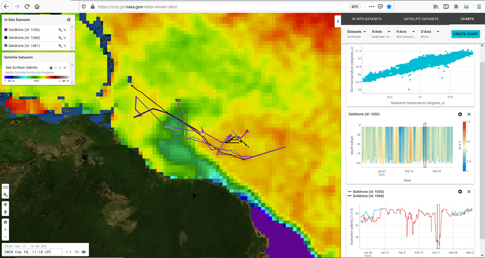
EUREC4A/ATOMIC field campaign Saildrone ADCP and CTD in-situ data overlaid on remotely sensed Sea Surface Salinity data from SMAP in the vicinity of the Amazon plume outflow, February 2020.
How is COVERAGE used?
COVERAGE’s intent is to help also new user communities, with less expertise working with EO data, to more fully realize the potential of such multi-platform ocean observations. There is a growing imperative to better marshal and utilise earth observations of different kinds and across agency repositories for societal benefit by a more digitally integrated approach leveraging emerging informatics technologies. The NASA-led COVERAGE initiative, in collaboration with EUMETSAT and other CEOS agency partners, aims to address this critical need consistent with FAIR Data and Open Science principles for global ocean observation also in support of the UN Decade of the Oceans for Sustainable Development objectives.
The COVERAGE thematic pilot, “High seas Tuna Fisheries in Relation to the Environment”, leverages data for the ecological and dynamic ocean management applications community, in line with UN Sustainable Development Goal 14: Conserve and sustainably use the oceans, seas and marine resources for sustainable development. We capitalise on data from 1993 to the present day, providing historical context for analyses such as habitat analyses for highly migratory species and studies on the stock structure of pelagic fish communities. The application illustrates how environmental data from satellites and other sources can effectively be accessed and combined to potentially support emerging Ecosystem-based approaches for fisheries management that are needed, especially in the face of climate change.
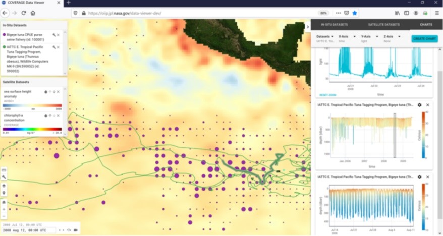
Coincident IATTC Bigeye Tuna archival tag and spatial catch distribution data within the Eastern Tropical Pacific relative to AVISO-SSHA and animal telemetry environmental measurements (Aug. 2008)
What virtual processing environments does WEkEO offer?
The CEOS COVERAGE application highlights the benefits of WEkEO’s marine environment data. Indeed, WEkEO provides direct access to data from the Copernicus Marine service, as well as data and products from other Copernicus Services focused on environmental data (atmosphere, climate, and land). Since WEkEO is implemented by the institutions in charge of generating Copernicus data and products, the data infrastructure between those institutions and WEkEO is directly linked, rather than being duplicated. WEkEO users thus benefit from the most up-to-date Copernicus environmental data, directly from the source.
More Information
COVERAGE - the CEOS Ocean Variables Enabling Research and Applications for GEO
CEOS - the Committee on Earth Observation Satellites
NASA JPL - North American Space Agency, Jet Propulsion Laboratory
EUMETSAT - European Organisation for the Exploitation of Meteorological Satellites
- Youtube

Vardis Tsontos, Science System Engineer & Oceanographer
His background includes a Ph.D in applied Ocean Science and over 20 years of experience in the field of oceanographic information systems, remote sensing, and geospatial data management. Work experience spans NASA, NOAA and UN agencies, in addition to academia and industry. Skill include project management, science system engineering, data science and informatics. Much of his career has focused on enabling synergistic use of multivariate ocean remote sensing, in-situ and model data via information system technologies in support of applications for societal benefit.